Hiking volcanoes in Guatemala: Summiting the most popular peaks
Some links in this post are affiliate links. This means if you purchase something through my links I may make a small commission at no extra charge to you. See my disclaimer.
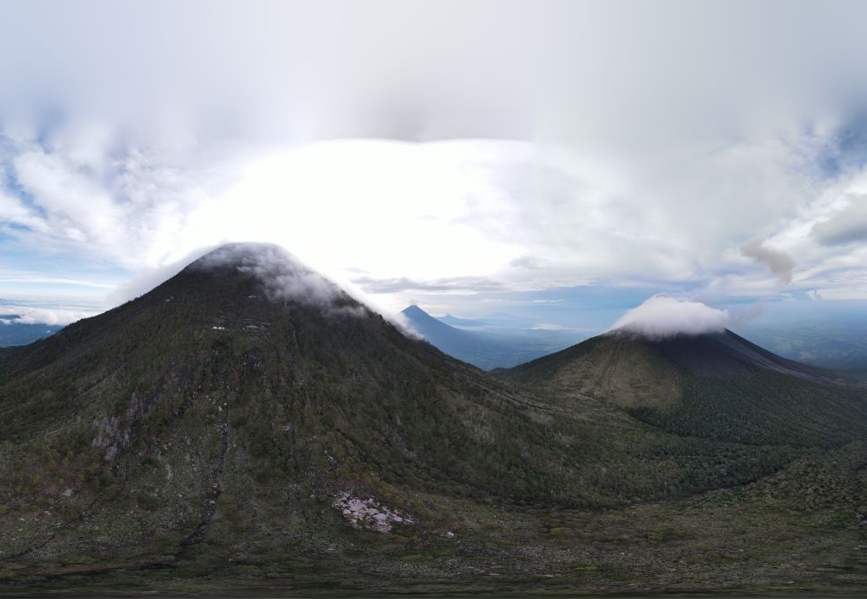
The photo above was taken by another hiker on my tour while climbing Volcan de Acatenango and Volcan de Fuego. They used their drone and shared the image with our entire tour group.
When a country is home to 37 volcanoes, it’s no surprise that plenty of hiking opportunities are available. That’s exactly the situation in the Central American country of Guatemala – there are so many volcano hikes just waiting to be explored.
Now, not every volcano in the country can be hiked. Some have dangerous trails that are not currently accessible, but the ones that can be accessed are certainly worth climbing.
Throughout this post, I’ve tried to list some of the country’s favourite hiking trails that take you to the summit of each respective volcano. Each volcano hike in Guatemala varies in difficulty and not every tour is the same. Just be warned that you could end up with wobbly legs if you climb too many in too little time.
This is exactly what I did when I did 3 days worth of volcano hikes in 3 days. Not a smart move!
However one thing is for sure regardless of which you choose, the views are unmatched and the experiences are not to be missed. So, let’s see what volcanoes you should consider hiking during your trip to Guatemala.
| Country: | Guatemala |
| Currency: | GTQ / Quetzales |
| Do you need a tourist visa? | Check here |
Don’t forget to get travel insurance to cover you if something bad happens. One company I have personal experience with is Safety Wing. Not everyone needs the same coverage, so make sure you get a personalised quote that suits you and your trip plans.
Please note: Many of these volcanoes are of a significantly high altitude. This means it is common for people to be struck down by altitude sickness. Make sure to give yourself plenty of time to acclimate before your hike and take water and anti-nausea medication.
Acatenango
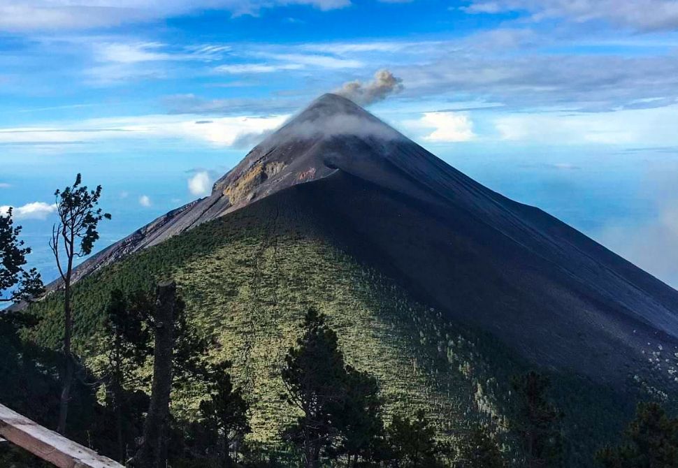
Acatenango volcano is arguably the most famous of the volcano hikes in Guatemala. It’s not the largest volcanic cone, but it’s the volcano hike that attracts the most tourists. Starting from Antigua, this hike takes you 6-8 hours up the side of the Acatenango volcano until you reach an overnight camping area.
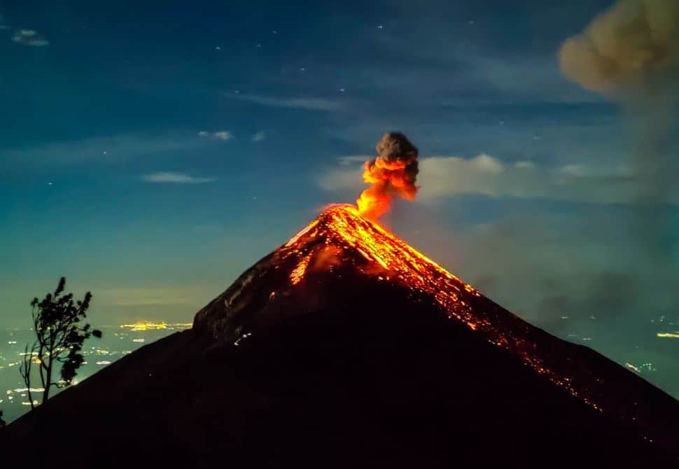
From the campsite, you will get to enjoy the stunning views of neighbouring Fuego volcano erupting. During the daytime on your way up, you will see plumes of smoke from the top of Fuego. At night time you will see the brightly coloured lava spit out from the top instead. After spending the night in the campsite on Acatenango, you will wake up around 2 hours before dawn to climb up to the volcanic peak.
From the peak, you’ll get to enjoy panoramic views of Fuego and the surrounding areas while enjoying the sunrise. After enjoying the sunrise you will start your descent back down the volcano back to the starting point. This takes almost half the time it takes to get up the day before.
Elevation gain: 3,976 metres
Length of trail: 8.5 miles / 13.7 km
Time to complete: One night and two days.
Where to book a tour: Private tour from Antigua or Group tour from Antigua
Santa Maria
The start of this trail takes you through a few flat farms before it starts to head up the trail on an incline. The path will transition from the farmland into a thick and lush forest. When attempting this hike without a local guide you will be able to follow the red ribbons and arrows that line the path. Typically these are found around eye level on trees and plants.
Much of the trail is muddy (in my experience, muddier than others on this list) so it’s best to avoid wearing clothes that you don’t wish to get dirty. Due to the forest and impending cloud cover parts of the trail will have restricted views, but it will all be worth it at the top. Clouds tend to roll in around midday in this region so it’s highly advised to start as early as possible!
Once you reach the summit of Santa Maria volcano, you will get a wide perspective view of the city of Santiaguito as well as Xela down below. Plus, on clear days you may be lucky enough to see Acatenango and Fuego. If you hike through the night you can often see the lava from Fuego from the summit too!
This trail is rated as difficult. You’ll need to use your hands while you scramble over rocks in some places, so please bear that in mind.
Elevation: 3,772 metres
Length of trail: 5 miles / 8 km
Time to complete: 6 – 7 hours roundtrip
Fuego
Fuego is connected to Acatenango so many tourists easily fit both into one experience. From the Acatenango campsite, you can climb down the opposite side of the volcanic cone towards the Fuego cone. This can take 2-3 hours from the campground to get to a safe place where you can watch eruptions from close-up.
The guides will get you to a place where you can safely watch the eruptions without being put at risk. It’s an amazing experience that’ll have to stand on the side of not only an active volcano but an erupting one. As you finish watching the eruptions from close by, you will retrace your steps back along the original route you took to get there.
Going back down Fuego and across the Acatenango ridge you’ll get to admire the views on your way back to the starting point at the entrance to the park. It’ll be an unforgettable experience.
Please note: Nobody is permitted to hike up Fuego without a guide.
Elevation: 3,768 m
Length of trail: 2.8 miles / 4.5 km
Time to complete: 5-6 hours one way with the option to stay overnight
Where to book a tour: Climb both Fuego & Acatenango in one 3-day tour
Tajumalco
This is the highest peak in Guatemala so it’s one of the volcano hikes you need to add to your itinerary! Tajumalco Volcano is another hike that can be split into a multi-day experience like Acatenango and Fuego. Many tourists choose to hike up on the first day until they reach the common camping area known as the “base camp”. Waking up at 4 am with enough time to reach the peak before sunrise gives you an unforgettable experience.
Some people with enough confidence attempt to hike the entire way to the peak before sunrise but this means your entire ascent will be in darkness. If you’re summiting this trail independently it is very easy to follow the trail as there are orange and blue place markers along the way. You’ll know you have almost reached the summit when you pass the multiple white crosses all pointing you the right way.
The views from the top of the summit are breathtaking – providing you can see through the clouds. This area has a high density of cloudy coverage so if you don’t time it right you might only get to see a sea of white clouds.
Elevation: 4,203 metres
Length of trail: 7.7 miles / 12.4 km
Time to complete: 6 – 7 hours out and back trail
Where to book a tour: Private group tour to Tajumalco volcano

Pacaya
Pacaya Volcano (Volcan de Pacaya) is one of the volcanic hikes with the lowest difficulty level. This means it is likely the most accessible volcano trail on our list. You can complete the entire hike in 2-3 hours which means you can easily fit this into an existing itinerary. The incline is quite steep from the outset after you enter the park and purchase your tickets (unless you join with a tour guide who typically handles this for you).
For those who struggle with steep inclines, you have the option to ride a horse up the trail instead of heading up on foot. This would need to be paid for in cash at the time, rather than in advance. One perk of the Guatemala volcano hikes on Pacaya is you will be able to enjoy great views from very early in the journey, it’s a fantastic effort-to-reward ratio.
Another one of the highlights of hiking Pacaya is that many tour companies will bring food and allow you to enjoy a picnic near the peak. This could include roasting some marshmallows or pizza slices on the volcanic steam beneath your feet. All while enjoying the views of the other famous volcanoes in Guatemala, Acatenango, Agua and Fuego in the distance!
Elevation: 2,552 metres
Length of trail: 3.2 miles / 5.1 km
Time to complete: 2.5 hours round trip
Where to book a tour: Private tour from Antigua or Private tour from Guatemala City
Chicabal
This Chicabal Volcano hiking trail will take you to Chicabal Lake where you will see some great views of the crater and surrounding forest. Unlike many of the other volcano hiking trails mentioned in this post, you can drive to the crater lake.
If you’re not feeling up for the walk and don’t have a car, this trail regularly has local drivers hanging out near the trailhead who will happily drive you the short distance instead. Just make sure you have cash. If you do choose to walk, however, it will take an average of 3 hours.
When you reach the “peak” you have the option to walk down to the water using a long staircase. This can be slippery in bad weather. Many visitors choose to spend some time on the banks of the lake to relax after the ascent. This gives you a nice boost of energy before looping back down towards the start of the trail. The overall steepness of the trail isn’t too bad and is rather gradual. This makes it a much more comfortable hiking route compared to other volcanoes.
If you go too late in the day, you can expect a thick fog to roll in on most days. This can give an almost mystical feel to the entire area, however, it can make it more difficult to descend down the trail. For this reason, if is advisable to complete the hike earlier in the day so you can beat most of the fog.
Elevation: 2,720 metres
Length of trail: 4.7 miles / 7.6 km
Time to complete: 3 hours on average
Where to book a tour: 1-day tour to Chicabal Volcano Lake
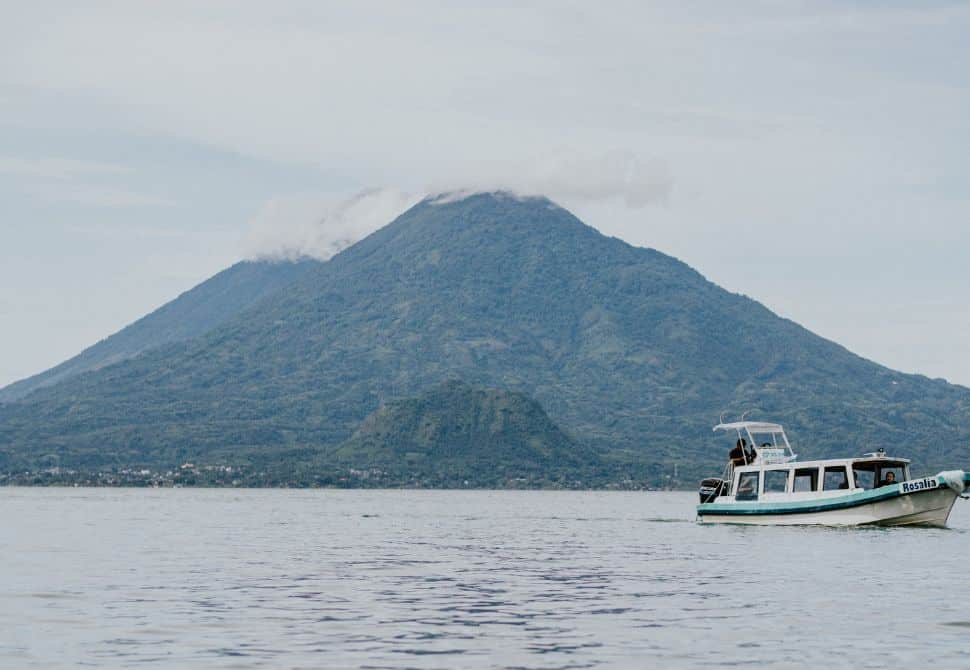
Atitlán
Starting from either San Lucas or Santiago, this is one of few volcano hikes in Guatemala that is almost a consistent straight line. The trail leading from Santiago seems to be maintained better than the other. The route is deemed to be moderate in difficulty due to how steep the majority of the trail is. You’ll find yourself surrounded by coffee fields as you make your way along the trail ascending upon the eventual crater.
Once you reach the summit crater of Atitlan Volcano you will be met with some mesmerising views of the famous Lake Atitlan to the north. This lake is one of the most popular tourist destinations in Guatemala and it’s a great area to spend some time before and after hiking various volcanoes in the country. As you progress along the trail you will first see San Pedro Volcano followed by Toliman Volcano before reaching the peak.
Although you will get to enjoy some views throughout the entire steep path, on a clear day, you can see as far as Acatenango and Fuego volcanoes in the east and even two other volcanoes to the west – Quetzaltenango and San Marcos. You’ll truly be spoiled by the landscape. Due to how steep this trail is, it can often take significantly longer to descend compared to other volcano trails listed. Take your time.
Please note: If you have any knee or mobility issues the descent will be extremely hard.
Elevation: 3,535 metres
Length of trail: 10.5 miles / 16.9 km
Time to complete: 10 – 11 hours to complete
Where to book a tour: Private 11-hour hike to Atitlan Volcano
Tolimán
Toliman is a stratovolcano located on the south side of Lake Atitlan. It is known as the twin volcano of Volcan de Atitlan. What makes hikes on this volcano in Guatemala a little different is the cave you will need to go past that’s worth exploring. It seems to be one of the highlights of the entire trail!
With regards to views, the hiking trails on this volcano are certainly not as exciting as you might expect considering its proximity to the lake. Although you will get to enjoy some small clearings along the way to see small parts of the lake at a time, you won’t get to see it in its entirety while hiking here.
There is one area on your way up where you can enjoy a fantastic view of Volcan de Fuego to the east side but much else of the trail has restricted views due to the vegetation. That is until you reach the peak and see the view across the water. The view you do get to enjoy is worth it, but it will be an extreme thigh burner. When you begin your descent back down the trail you will be able to see San Pedro Volcano after reaching the maize and coffee fields.
Elevation: 3,158 metres
Length of trail: 8.3 miles / 13.3 km
Time to complete: 7 – 8 hours to complete
Where to book a tour: 1-day volcano hike to Toliman Volcano
How to Be Prepared for hiking volcanoes in Guatemala
Whether hiking volcanoes in Guatemala or anywhere else for that matter, there are always a few items you should carry with you. Not only will these items aid with safety but they can also make your life easier. Some of these items can be swapped out depending on the season or weather situation. However, this is a great list to use as a baseline when packing your hiking pack.
Below you can download a packing list to help you plan for your next day hike.
If you want to stay connected throughout your hike and your time in Guatemala, I’d suggest getting an eSIM with Airalo. These SIMS can be purchased and downloaded directly to your device for ease of use. By having an active SIM card during your trip you make it easier to connect to emergency services if you run into any issues.
If you’d like to do more than just hiking volcanoes, check out these other posts ready for your trip to Guatemala:
- Interesting Things to do in Antigua Guatemala
- Hobbitenango: Guatemala’s Lord of the Rings Inspired park
If you need to exchange currency before your during your trip, the Wise app is a great option with competitive rates. You can transfer funds between international bank accounts and check daily rates easily.
Best time of year for hiking volcanoes in Guatemala?
This is a country with a hot climate pretty much all year round. Although it is technically possible to hike during any month in Guatemala, it is generally advised to avoid the rainy season when hiking volcanoes. This is due to having many steep trails which can become extremely slippery during or after a rain storm.
The months with the most rainfall are May, June, August and September.
If you want to avoid volcano hikes during the hottest months of the Guatemala summer, you should also avoid travelling during July and August.
I’d generally recommend travelling here during the northern hemisphere winter months. November, December, January and February. During this time, the country is nice and warm but it is not overly humid like you’d experience in the summer. This makes for much more comfortable hiking weather.
Have you climbed any volcanoes in Guatemala? What did you think?
Need help planning your trip?
Check out how to plan a trip abroad & see my travel resources for more.
Skyscanner – A comprehensive comparison website showing where to purchase flights.
HostelWorld – The biggest selection of hostels & sociable accommodations.
Booking.com – The largest collection of accommodations AND flights worldwide.
Safety Wing – A travel insurance brand for long-term travellers and nomads.
Airalo – An eSIM card company that lets you stay connected during your trip.
Wise – Perfect for transferring foreign currencies.
iVisa – For applying for tourist and visitor visas.
Viator – Great for finding tours and activities worldwide.
Get Your Guide – Another company for finding activities.
Klook – Have some of the best activity deals in Asia.